What is Anemos?
Anemos is a numerical weather and marine forecast service for the Adriatic Sea, made for sailors, professionals at sea and everyone interested in sea conditions. Besides the Adriatic it covers inland Croatia and the surrounding region.
Forecasts are direct output of numerical models that GEKOM runs and tunes for the Adriatic. High-resolution models take the local topography into account, so they resolve the channels, islands and coastal effects that global models miss.
What Anemos shows
The interactive map shows wind, temperature, rain, clouds, pressure, humidity, reflectivity, instability and visibility from the atmospheric model, and wave height, period, length and direction, surface currents, sea temperature, salinity and sea level from the ocean models – six days ahead, hour by hour.
Click any point to get a meteogram: time series of wind, temperature, rain, clouds and pressure, and at sea also waves, currents, sea temperature and sea level.
The forecast system
Numerical models are the basic tool of modern weather and ocean forecasting. However sophisticated, every model has limits – for example, its horizontal resolution (the distance between grid nodes) is sometimes too coarse to capture fine-scale topography that strongly affects the wind near the surface. Increasing the resolution refines the results, as the comparison below shows.
The system is a chain: the global GFS model provides boundary conditions for the regional WRF-ARW atmospheric model, whose winds then drive the WWM-III wave model and the ROMS ocean model. The forecast is computed once a day for six days ahead.
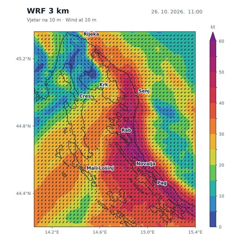
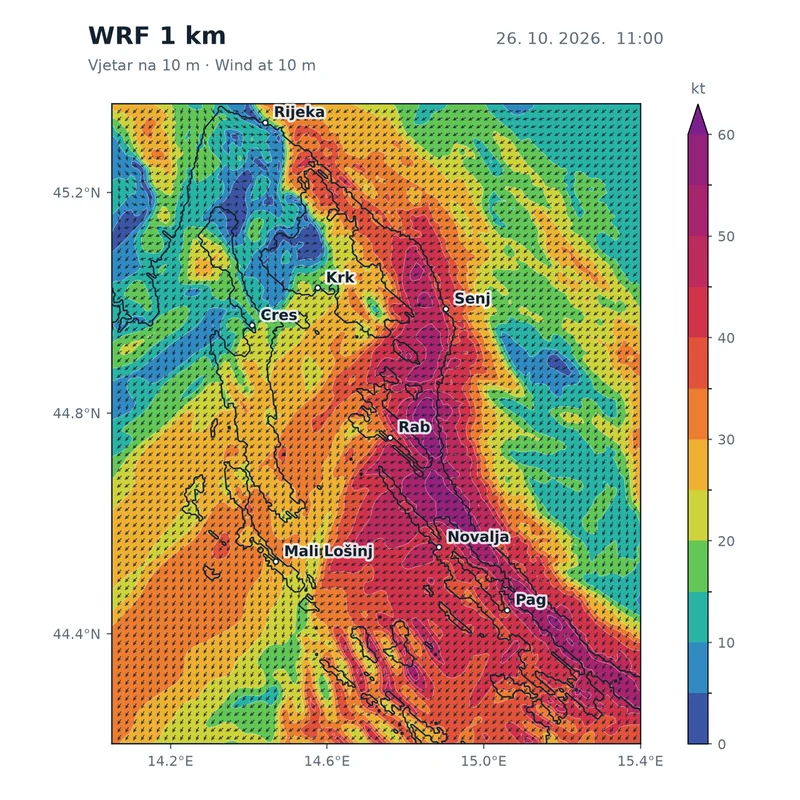
Bora over Kvarner, 26 Oct 2026 at 11:00 – the same forecast at two resolutions; colour is wind speed, and each arrow is one model grid point (every second one at 1 km). At 1 km the separate bora jets down Velebit, the wind shadows behind Krk, Rab and Pag, and the lee waves south of Pag become visible.
GFS (Global Forecast System)
The global forecast system of the US National Centers for Environmental Prediction (NCEP), part of NOAA. Global models run at a resolution of a few tens of kilometres, the level at which many websites give their forecasts. Anemos uses it as input to its own, much finer model.
Atmospheric model WRF-ARW
The Weather Research and Forecasting model is a mesoscale numerical system for operational forecasting and atmospheric research, developed at NCAR (USA). Anemos runs it on a 3 km grid for the whole Adriatic and on an additional 1 km grid over Kvarner, where the bora is strongest. Output is hourly.
Data produced by the WRF-ARW model are owned by GEKOM d.o.o., where the operational forecast is run.
- Wind
- speed and direction at 10 m above ground. On the map, streamlines show where the wind blows to; meteogram arrows show the flow direction too.
- Air temperature
- at 2 m above ground, in °C.
- Pressure
- mean sea-level pressure, in hPa.
- Precipitation
- in mm/h, mean over the past hour.
- Cloud cover
- in percent, at three heights – low, mid and high. Total cover assumes random overlap of the layers.
- Relative humidity
- in percent.
- Reflectivity
- simulated radar reflectivity in dBZ. Values above about 35 dBZ indicate convective clouds and showers.
- MCAPE
- convective available potential energy (J/kg), a measure of tropospheric instability – higher values mean a greater chance of thunderstorms.
- Visibility
- near the surface in km, from hydrometeors and humidity.
Wave model WWM-III
Wind Wave Model III is a third-generation spectral wave model developed by National Cheng Kung University (Taiwan) and the Technical University of Darmstadt. It solves the wave action equation on an unstructured triangular mesh refined along the coast – Anemos uses a mesh of almost 100,000 nodes, down to about 100 m along the coast and around islands.
The model includes wind-driven wave growth, propagation, depth refraction and shoaling, nonlinear wave interactions, whitecapping, bottom friction and breaking. It is driven by the WRF wind field. Wave maps help plan passages and work at sea by showing how the sea state develops over several days.
- Significant wave height
- in metres – the mean height of the highest third of the waves.
- Mean wave period
- in seconds, from the wave energy spectrum.
- Mean wave length
- in metres.
- Wave direction
- the direction waves travel towards (animated with particles on the map).
Ocean model ROMS
The Regional Ocean Modeling System is a three-dimensional, free-surface ocean model with terrain-following vertical coordinates. Anemos runs it on a 2 km grid for the whole Adriatic and on nested high-resolution grids for Kvarner, Istria and the southern Adriatic.
It is driven by wind and heat fluxes from WRF. Open-boundary conditions come from the Mediterranean model (Copernicus Marine), with tides from seven constituents and river inflow – real-time for the Po, climatology for other rivers.
- Surface currents
- speed (m/s) and direction at the surface, animated with particles moving with the current.
- Sea temperature
- at the surface, in °C.
- Salinity
- at the surface, in PSU (≈ ‰).
- Sea level
- anomaly from the mean in cm – includes tides and the effect of wind and pressure.
Disclaimer
Anemos forecasts are not officially interpreted forecasts but direct numerical model output, for information only. GEKOM d.o.o. is not responsible for the accuracy, completeness, timeliness or quality of the data, nor for any injuries, damages or costs resulting from the use or misinterpretation of information provided by Anemos. For official warnings, follow the Croatian Meteorological and Hydrological Service (DHMZ).